


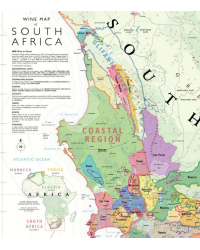
The Wine Map of South Africa wall chart by Steve De Long (61x91 cm) is a lithograph detailing all the wine regions of the country. It includes regions, districts, geographical units, and wards (WO), a detailed view of Stellenbosch, and an overview of the Northern Cape and Free State regions. A must-have for enthusiasts and professionals wishing to discover South African history and terroirs.
Visa, MasterCard, Amex, Paypal or 3 times, interest-free with Scalapay

0.01€ from 35€ of purchase in France*

Worldwide Shipping

Discover wine-producing South Africa with the Wine Map of South Africa wall map, created by wine map expert Steve De Long. Ideal for wine enthusiasts, this superb lithograph elegantly and comprehensively presents all of the country's appellations.
This 61 x 91 cm map highlights all certified Wine of Origin (WO) areas, including Geographical Units, Regions, Districts, and Wards. Its refined aesthetics make it both a decorative piece and a valuable resource for deepening your knowledge of South African wine.
South Africa's wine history began in 1655, when the Dutch planted the first vines near Constantia. By the 1780s, the sweet wines of Constantia had already gained international acclaim. Thus, South Africa possesses a unique identity, combining European tradition (Old World) with an innovative approach (New World).
This map also includes an overview of African wine regions, along with a detailed map of Stellenbosch, the emblematic heart of South African wine production. Lesser-known but promising regions such as Northern Cape and Free State are also highlighted, providing a comprehensive understanding of South African terroir.
Printed in lithography on 100# matte coated paper, this high-quality map ensures a clear and durable finish over time.
Whether you are a wine industry professional, an informed enthusiast, or simply passionate about maps and wine, this Wine Map of South Africa will quickly become an essential reference in your collection.
Data sheet
You might also like

The Wine Map of South Africa wall chart by Steve De Long (61x91 cm) is a lithograph detailing all the wine regions of the country. It includes regions, districts, geographical units, and wards (WO), a detailed view of Stellenbosch, and an overview of the Northern Cape and Free State regions. A must-have for enthusiasts and professionals wishing to discover South African history and terroirs.


